Easter Island

Easter Island is one of the world's most famous yet least visited archaeological sites, a small, hilly, now treeless island of volcanic origin. Located in the Pacific Ocean at 27 degrees south of the equator and some 2200 miles (3600 kilometers) off the coast of Chile, it is considered the world's most remote inhabited island. Sixty-three square miles in size and with three extinct volcanoes (the tallest rising to 1674 feet), the island is, technically speaking, a single massive volcano rising over ten thousand feet from the Pacific Ocean floor. The oldest known traditional name of the island is Te Pito o Te Henua, meaning 'The Center (or Navel) of the World.' In the 1860s, Tahitian sailors named the island Rapa Nui, meaning 'Great Rapa,' due to its resemblance to another island in Polynesia called Rapa Iti, meaning 'Little Rapa.' The island received its most well-known current name, Easter Island, from the Dutch sea captain Jacob Roggeveen, who became the first European to visit Easter Sunday, April 5, 1722.
In the early 1950s, the Norwegian explorer Thor Heyerdahl (famous for his Kon-Tiki and Ra raft voyages across the oceans) popularized the idea that the island had been originally settled by advanced societies of Indians from the coast of South America. Extensive archaeological, ethnographic, and linguistic research has conclusively shown this hypothesis to be inaccurate. It is now considered likely that the original inhabitants of Easter Island are of Polynesian stock (DNA extracts from skeletons have confirmed this), that they most probably came from the Marquesas or Society islands, and that they arrived as early as 318 AD (carbon dating of reeds from a grave confirms this). It is estimated that the original colonists, who may have been lost at sea, arrived in only a few canoes and numbered fewer than 100. At the time of their arrival, much of the island was forested, was teeming with land birds, and was perhaps the most productive breeding site for seabirds in the Polynesia region. Because of the plentiful bird, fish, and plant food sources, the human population grew and gave rise to a rich religious and artistic culture.
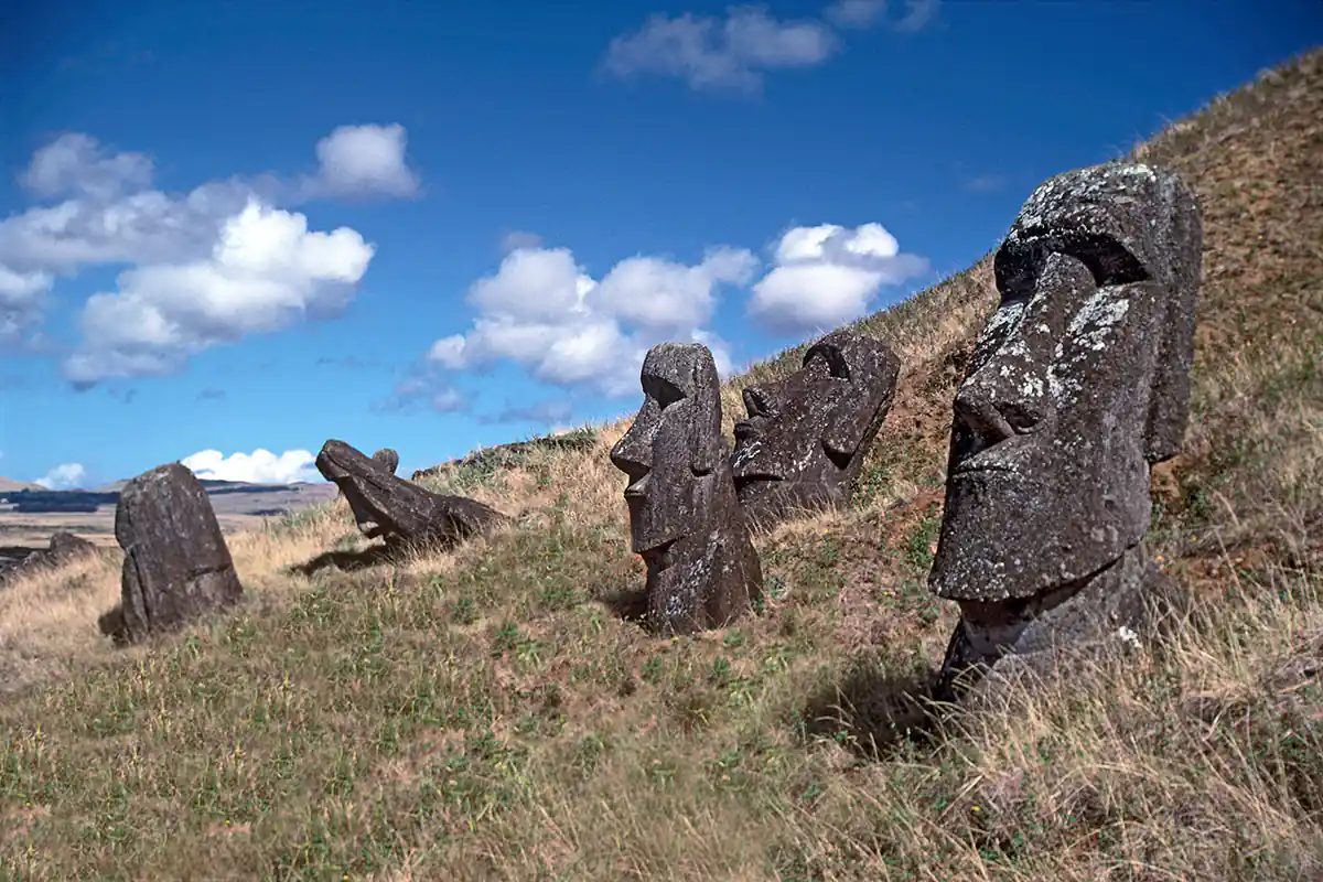
That culture's most famous features are its enormous stone statues called moai, at least 288 of which once stood upon massive stone platforms called ahu. Some 250 of these ahu platforms are spaced approximately one-half mile apart, creating an almost unbroken line around the island's perimeter. Another 600 moai statues, in various stages of completion, are scattered around the island, either in quarries or along ancient roads between the quarries and the coastal areas where the statues were most often erected. Nearly all the moai are carved from the tough stone of the Rano Raraku volcano. The average statue is 14 feet, 6 inches tall, and weighs 14 tons. Some moai were as large as 33 feet and weighed more than 80 tons (one statue only partially quarried from the bedrock was 65 feet long and would have weighed an estimated 270 tons). Depending upon the size of the statues, it has been estimated that between 50 and 150 people were needed to drag them across the countryside on sleds and rollers made from the island's trees.

The Paschalococos disperta and the Saphora toromiro were once the island’s most bountiful trees, and sediment samples dating from 200 AD indicate an abundance of pollen from both trees in the island biota at that time. The Paschalococos disperta bears a striking resemblance to the still-surviving Jubaea chilensis, the Chilean wine palm, which grows up to eighty feet tall and six feet in diameter. Thus, the Paschalococos disperta palm tree trunks are the most probable candidates for the solution to the transportation of the enormous moai from their carving location at the Rano Raraku volcano to the many places where they were erected around the island. These trees were also important to the islanders for fuel and for constructing houses and ocean-fishing canoes.
The moai and ahu were in use as early as AD 500; the majority were carved and erected between AD 1000 and 1650, and they were still standing when Jacob Roggeveen visited the island in 1722. Recent research has shown that specific statue sites, particularly the most important ones with great ahu platforms, were periodically ritually dismantled and reassembled with ever-larger statues. A small number of the moai were once capped with ‘crowns’ or ‘hats’ of red volcanic stone. The meaning and purpose of these capstones are not known, but archaeologists have suggested that the moai thus marked were of pan-island ritual significance or perhaps sacred to a particular clan.
Scholars cannot definitively explain the function and use of the moai statues. It is assumed that their carving and erection derived from an idea rooted in similar practices in Polynesia but evolved uniquely on Easter Island. Archaeological and iconographic analysis indicates that the statue cult was based on an ideology of male, lineage-based authority incorporating anthropomorphic symbolism. The statues were thus symbols of authority and power, both religious and political. But they were not only symbols. To the people who erected and used them, they were actual repositories of sacred spirit. When properly fashioned and ritually prepared, carved stone and wooden objects in ancient Polynesian religions were believed to be charged by a magical spiritual essence called mana. The ahu platforms of Easter Island were the sanctuaries of the people of Rapa Nui, and the moai statues were the ritually charged sacred objects of those sanctuaries. While the statues have been toppled and re-erected over the centuries, the mana or spiritual presence of Rapa Nui is still strongly present at the ahu sites and atop the sacred volcanoes.
Mystery surrounds the purpose of the ahu platforms and moai statues, but even more perplexing mysteries have begun to surface from scholars' research outside the boundaries of conventional archaeology. As mentioned, orthodox archaeologists hypothesize that Easter Island was initially settled around 320 AD by a small group of Polynesians lost on the open sea. Other scholars, however, have suggested that the tiny island may once have been part of a larger island whose original discovery and use may have been several thousands of years earlier in time (it is known, for example, that Melanesians were journeying around the Pacific in boats as early as 5500 BC).
Three researchers in particular, Graham Hancock, Colin Wilson, and Rand Flem-Ath, believe Easter Island was an important node in a global grid of sacred geography predating the great floods of archaic times. Easter Island, writes Graham Hancock, is “part of a massive subterranean escarpment called the East Pacific Rise, which reaches almost to the surface at several points. Twelve thousand years ago, when the great ice cap of the last glaciation was still largely unmelted, and the sea level was 100 meters lower than it is today, the Rise would have formed a chain of steep and narrow antediluvian islands, as long as the Andes mountain range.” At that time, the land we now call Easter Island would have been the highest peak of a much larger island. Humans were traveling in these areas at that time, and so might have settled at various places, including what is now the island of Easter Island.
Besides its more well-known name, Rapa Nui, Easter Island is also known as Te-Pito-O-Te-Henua, meaning ‘The Navel of the World,’ and as Mata-Ki-Te-Rani, meaning ‘Eyes Looking at Heaven.’ These ancient names and a host of mythological details ignored by mainstream archaeologists point to the possibility that the remote island may once have been a geodetic marker and the site of an astronomical observatory of a long-forgotten civilization. Speculations about this shadowy antediluvian culture include the notion that its mariners had charted the world’s oceans, that its astronomers had sophisticated knowledge of long-term astronomical cycles such as precession and cometary orbits, and that its historians had records of previous global cataclysms and the destruction they caused of even more ancient civilizations.
In his book, Heaven’s Mirror, Hancock suggests that Easter Island may once have been a significant scientific outpost of this antediluvian civilization and that its location had extreme importance in a planet-spanning, mathematically precise grid of sacred sites. He writes, “The very existence of such an ancient world grid has been staunchly resisted by mainstream archaeologists and historians – as, of course, have all attempts to relate known sites to it. Nevertheless, the definite traces of lost astronomical knowledge that are to be seen on Easter Island, and the recurrent echoes of ancient Egyptian spiritual and cosmological themes, cast doubt on the scholarly explanation that the odd name ‘Navel of the World’ was adopted for purely ‘poetic and descriptive’ reasons. We suspect that Te-Pito-O-Te-Henua may originally have been selected for settlement, and given its name, entirely because of its geodetic location.” “What we are suggesting therefore is that Easter Island might have originally have been settled in order to serve as a sort of geodetic beacon, or marker – fulfilling some as yet unguessed at function in an ancient global system of sky-ground co-ordinates that linked many so-called ‘world navels’”.
Two other alternative scholars, Christopher Knight and Robert Lomas, have extensively studied these geodetic markers' location and possible function. In their fascinating book, Uriel's Machine, they suggest that one purpose of the geodetic markers was as part of a global network of sophisticated astronomical observatories dedicated to predicting and preparing for future cometary impacts and crustal displacement cataclysms. The great floods of archaic myths did not result from the ice caps melting between 13,000 and 8000 BC but rather from two great cataclysms caused by cosmic and cometary objects affecting the entire planet. These cataclysms were 1) the pass-by of an enormous, perhaps moon-sized cosmic object and an ensuing planet-wide crustal displacement in 9600 BC, and 2) the seven cometary impacts of 7640 BC, which resulted in the massive waves (3-5 miles high, traveling at over 400 miles per hour for distances of more than 2000 miles), volcanic activity and other terrestrial and climatological events recorded in myths all across the planet. Before these cataclysmic events, however, in what is commonly called the late Paleolithic era, a maritime civilization may have existed with cities situated along coastlines that are now submerged beneath the seas.

The decline of culture on Easter Island
In the past few decades, various theories have been suggested about the rapid decline of Easter Island's remarkable culture. Jared Diamond, in his excellent book Collapse: How Societies Choose to Fail or Survive, explains that a few centuries after Easter Island's initial colonization, the resource needs of the growing population had begun to outpace the island's capacity to renew itself ecologically. By the 1400s, the forests had been entirely cut, the rich ground cover had eroded, the springs had dried up, and the vast flocks of birds coming to roost on the island had disappeared. With no logs to build the canoes necessary for offshore fishing, depleted bird and wildlife food sources, and declining crop yields because of the erosion of good soil, the nutritional intake of the people plummeted. First famine, then cannibalism, set in. The resulting chaos triggered a social and cultural collapse because the island could no longer feed the chiefs, bureaucrats, and priests who kept the complex society running. By 1700, the population had dropped to between one-quarter and one-tenth of its former number, and many of the statues had been toppled during supposed "clan wars" of the 1600s and 1700s. This all happened before the Europeans came.
After they came, things got even worse. To fully understand the tremendous social devastation that occurred on Easter Island, it is vital to recognize that it was a consequence of two separate matters: the pre-European environmental degradation and ensuing cultural collapse and the inhumane behavior of many of the first European visitors, particularly the slavers who raped and murdered the islanders, introduced smallpox and other diseases, and brutally removed the natives to mainland South America. Readers interested in more detailed information concerning the causes of Easter Island’s ecological devastation, its so-called civil war, and the genocide caused by European slavers will appreciate the article,From Genocide to Ecocide: The Rape of Rapa Nui, written by Benny Peiser.
Recent research:
New findings indicate that Native Americans had visited Easter Island before Columbus sailed to the Americas. The study, Genome-wide Ancestry Patterns in Rapanui Suggest Pre-European Admixture with Native Americans, was conducted by a team of geneticists from the Natural History Museum of Denmark and published in the journal Current Biology on November 3, 2014. The scientists analyzed genetic markers for 27 native Rapanui (Easter Islanders) and determined that 10 percent of their genetic admixture came from American Indians, while 75 percent was Polynesian and 15 percent was European. The study’s co-authors, Eske Willerslev and Anna-Sapfo Malaspina, argue that this evidence supports the possibility of Native American contact prior to the European ‘discovery’ of the island in AD 1722, in particular that interbreeding between the Rapa Nui and native people in South America occurred roughly between 1300 and 1500, or 19 to 23 generations ago.
Another interesting matter is that recent studies of the DNA of sweet potatoes appear to confirm that the Polynesians had cultivated it before contact with Europeans, strong evidence of American Indian-Polynesian contact. A 2013 study by a French team, led by Caroline Roullier and Vincent Lebot, in the Proceedings of the National Academy of Sciences, analyzed the DNA of sweet potatoes collected during the voyages of James Cook (who sailed the Pacific in the years 1768-1779). Using these early and thus uncontaminated specimens, the researchers argued that their “results provide strong support for prehistoric transfer(s) of sweet potato from South America (Peru-Ecuador region) into Polynesia.”

Martin Gray is a cultural anthropologist, writer and photographer specializing in the study of pilgrimage traditions and sacred sites around the world. During a 40 year period he has visited more than 2000 pilgrimage places in 160 countries. The World Pilgrimage Guide at sacredsites.com is the most comprehensive source of information on this subject.